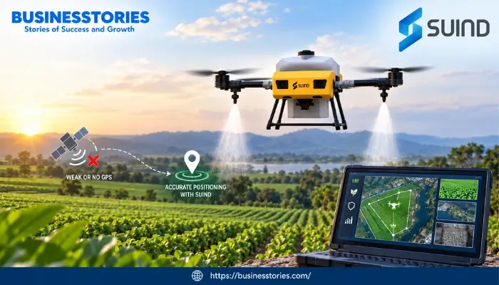
Picture a drone flying just a few feet above a banana farm. It dips under leaves. Then, it curves around tree trunks. Meanwhile, it sprays each plant with excellent care. There is no satellite signal guiding it. Instead, cameras and onboard software read the land in real time. This is not a lab idea. It is a real product from SUIND, a drone startup that is changing how flying robots find their way.
For years, drone makers have leaned on GPS to guide their machines. This technology works well in the sky. But it breaks down close to the ground. For instance, it fails near tall crops. It also fails in hilly valleys. And it fails in any spot where satellite signals get blocked.
So, SUIND boldly tackled this problem. Instead of chasing a stronger GPS signal, the company built drones that barely need GPS at all. In this article, you will learn why GPS struggles near the ground.
Thereafter, you will see how SUIND’s camera-based system fixes the gap. Finally, you will discover how the technology benefits farmers and security teams.
What Is SUIND, and Why Is It Making Headlines?
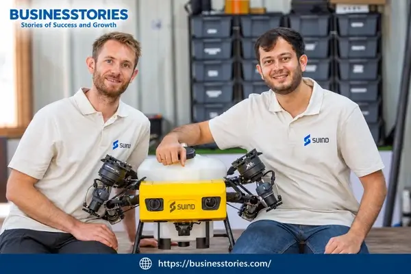
SUIND is a drone startup founded in 2020. Its founders are Kunal Shrivastava and Kevin Kleber. Both men have a strong background in computer vision and robotics. In fact, the company’s roots trace back to research at ETH Zurich, a top engineering school in Switzerland.
Because of this link, people often call SUIND an Indo-Swiss startup. It has a research base in Zurich. Furthermore, it has a growing team in India. The company’s mission is easy to state. It wants to build flying robots that think for themselves in messy, real-world places.
Most drones today act like remote-controlled toys, since a person must steer them. However, SUIND wants something different. It wants drones that sense their world, make choices, and act with very little human help. This idea guides every product the company builds.
First spraying drone
SUIND first tested this idea in farming. Its spraying drone, called Bumblebee, already works across farms in India. For example, it flies over banana, sugarcane, and rubber crops. The drone also holds DGCA certification, which is a key approval from India’s aviation regulator.
As a result, Bumblebee can fly real commercial jobs, not just test flights. More recently, SUIND made news for a different reason: fresh funding. The startup raised ₹20.5 crore, or about $2.2 million. Transition VC led the round, and IIMA Ventures also joined in.
The company will use this money to grow Bumblebee’s reach. Additionally, the company will accelerate the development of a new drone named WASP, designed for surveillance, security, and industrial inspections.
Still, the funding is not the most exciting part of this story. In fact, the real story is the technology behind both drones. Both products share one core system, and this system lets drones fly with confidence in areas where GPS is unreliable. To see why that matters, let’s look at the GPS problem itself.
The GPS Problem: Why Drones Struggle Near the Ground
Most commercial drones use GPS much like a car uses a map app. First, the drone picks up satellite signals. It then uses them to determine its precise location in the sky. This works fine at high altitude over open land. However, once a drone flies close to the ground, things go wrong fast.
- First, satellite signals grow weak, since tall crops, trees, hills, and buildings block the clear signal path a drone needs.
- Second, GPS itself is not that precise, and it can be off by a few meters. That gap means nothing at 100 meters up. But it can cause a crash when a drone flies two meters above a crop row.
- Third, in some places, people can jam or fake GPS signals on purpose. This is a real worry for border patrols and surveillance teams.
As a result, GPS-only drones often need flat, open, empty fields to fly safely. That rules out a giant share of the world’s farmland. After all, hilly ground, thick orchards, and uneven plots are common across Asia, Africa, and Latin America.
Therefore, these places simply do not fit the GPS drone model. In the same way, surveillance drones often need to fly low, near pipelines, fences, or towers. These are the exact spots where GPS tends to fail. This gap is not a small annoyance.
It is one of the most significant reasons drones have not spread faster in farming and security work. So the real question is not, “How do we build a stronger GPS signal?” Instead, it is “how do we build a drone that does not need GPS at all?”
This shift in thinking is where SUIND’s work begins, and it has guided the company since it started in 2020.
How SUIND’s Vision-First Technology Solves the Problem
SUIND’s answer to the GPS problem is simple to explain: swap satellites for sight. Instead of using orbiting satellites to find its spot, SUIND’s drone uses onboard cameras and smart software. It reads the ground much like a human pilot would look out a window and judge distance and obstacles.
Cameras Instead of Heavy Sensors
Many self-driving machines use LIDAR, a sensor that sends out laser pulses to map the world around it. LIDAR works well, but it is heavy. It also drains battery power fast and costs a lot. So, SUIND chose a lighter path instead.
The company says its camera setup reads over 12 million data points every second. As a result, the setup gives the drone a rich, constantly updated view of its surroundings, without the weight of LIDAR. Consequently, Bumblebee sits among the lightest spraying drones in its class, since a lighter drone flies longer and costs less to run per acre.
Built-In Safety Features
This camera-based core supports several handy features. For instance, the drone spots and avoids obstacles like branches and wires on its own. It also follows the shape of the land, rising and dipping in step with the terrain below.
Meanwhile, a smart battery system keeps checking how much power it needs to fly home safely. Then, once the spray tank runs dry, the drone returns to base on its own. Together, these small touches build a drone that a farmer can trust in real, messy field conditions, not just in a clean test flight.
Software Built First, Hardware Built Second
Here is what sets SUIND apart from many rivals. Most drone firms build the machine first, and they add navigation software later. SUIND flipped that order instead. It built its vision and autonomy software first, and only then did it design hardware around specific tasks.
One investor called the company out directly, saying SUIND stands out for its deep skill in vision-based flight built for GPS-denied spaces, a software-first strategy that most rivals have not matched.
This vision-first base explains why the same core system can move from spraying crops to checking pipelines to watching a border. The task changes, yet the core skill of seeing and reacting without GPS stays the same.
Bumblebee: Proof the Technology Works on Real Farms
Ideas are easy, but real-world use is hard. In fact, SUIND’s best evidence is not a lab demo. Instead, it is Bumblebee’s track record on working farms. Bumblebee already flies over plantations growing banana, sugarcane, and rubber. These are not simple, flat fields.
Banana farms, in particular, have tall, thick canopies, so a GPS-only drone would struggle to fly low and safely in that setting. The results are clear. According to the company, farms using Bumblebee have cut chemical use by around 60 percent.
Furthermore, water use has dropped by over 90 percent, and spraying costs have fallen by about half. The crops have also become more evenly covered. For example, one farmer in Maharashtra used to spray his banana crop four times a season.
After switching to Bumblebee, he discovered that he needed only two rounds. Furthermore, his crop quality rose enough to earn a 20 percent higher price at market. These are not small wins; rather, they are the kind of numbers that change a farmer’s yearly budget.
Beyond spraying, SUIND has added a data layer on top of its drones. The same cameras that guide flight can also spot early signs of crop disease. For instance, the drone can catch Black Sigatoka fungus in banana plants weeks before a human eye would notice it.
As a result, Bumblebee becomes an early-warning tool, not just a spraying machine, and farmers gain time to treat problems before they spread. There is also a safety point that few articles mention. Manual spraying puts farm workers in direct contact with harsh chemicals for hours.
Thus, by handing that job to a precise drone, SUIND cuts costs, and it also protects the health of the people who work the land. That is a real, often overlooked win for rural workers, not just for farm budgets.
WASP: Bringing GPS-Free Flight to Surveillance and Security
Farming was SUIND’s proving ground, but it was never the end goal. Now, the company builds WASP, a drone aimed at industrial checks, infrastructure inspection, security, and surveillance work.
The logic here is clear. Bumblebee proved that SUIND’s camera-based system can fly safely near the ground, around obstacles, without GPS. Similarly, those same conditions describe many surveillance jobs.
Think of a pipeline that winds through a forest, a border fence on rough ground, or a power tower deep in a valley. In each case, a drone must fly low, near structures, often without steady satellite coverage. That is the exact skill Bumblebee already has.
WASP has already been flight-tested, and it targets industrial monitoring, infrastructure checks, security, and reconnaissance work. Because WASP shares its core autonomy system with Bumblebee, SUIND does not need to build new navigation software from scratch.
Instead, it adapts a proven engine for new jobs, so this approach saves both time and money as the company grows.
This move also fits a wider trend. Drones that skip GPS matter most where satellite signals are weak or blocked on purpose, a concern for both public infrastructure and defense. Given this trend, investors backing SUIND’s round have pointed to infrastructure checks, defense, and surveillance as the next big market once WASP is ready.
Here is an insight that few competing stories mention. SUIND’s two-product plan gives it something many drone startups lack: steady income from farming while it builds toward the bigger surveillance and defense market.
This order lowers risk, since the company does not need to bet everything on an unproven product. Over the next year or two, SUIND plans to grow Bumblebee’s output while getting WASP ready for sale, with India as its main market and engineering base.
SUIND’s Funding, Team, and Growth Path
Every strong tech story needs money behind it, and SUIND’s recent seed round tells its part of this tale. The company raised ₹20.5 crore, close to $2.2 million, led by Transition VC. IIMA Ventures also took part.
This follows an earlier round that brought SUIND’s total funding to around $600,000, based on public company data. The new funds go toward four clear goals.
- First, grow Bumblebee’s reach in the field.
- Second, speed up WASP’s build.
- Third, sharpen the core autonomy system.
- Fourth, grow the engineering team.
Overall, this strategy is a focused use of seed money.
Rather than spread thin across many new markets, SUIND doubles down on what already works while it steadily builds its next product.
CEO Kunal Shrivastava has framed the firm’s goal around a bigger shift in robotics: moving drones from remote-controlled tools into true robotic workers that sense, decide, and act with little human help.
This goal shows SUIND’s long-term aim, since the plan is not just to sell more drones. Instead, it is to build the core intelligence that lets flying robots handle tough, repetitive, and even risky jobs safely and well.
By location, SUIND keeps India as its main market and build base, while it also keeps its research roots in Zurich, Switzerland. This split setup gives SUIND access to India’s huge farm market and growing drone-building base, and it taps into Switzerland’s deep pool of robotics talent at the same time.
So, few rival startups can claim that same mix of hands-on market access and top-tier research skill. Looking ahead, SUIND has hinted at growing into new countries once WASP is ready to sell.
Given the rising world interest in GPS-free flight, especially for defense and infrastructure work, SUIND’s timing looks well matched to where the drone industry is headed next.
Why GPS-Free Drone Technology Matters for the Future
Step back, and SUIND’s story points to a bigger shift across robotics. Machines are moving away from single-point navigation systems. GPS is handy, but it is also an outside signal that a machine cannot control. So, anything that blocks, weakens, or fakes that signal can ground an entire fleet.
By building drones that mainly use onboard sight, SUIND guards its technology against a whole class of failure. This matters a lot for farming, since farms sit on every kind of land you can name, from flat plains to steep hillsides.
It matters even more for surveillance and defense work, where GPS trouble is not a rare accident. Sometimes, in fact, it is a deliberate move by an opponent. There is also a money angle worth noting, one that gets little attention elsewhere.
Precision farm tools have long cost too much for small farms in poorer regions. However, SUIND’s light, camera-based system skips the cost of pricey LIDAR gear.
As a result, the technology could make advanced drone flight cheaper for small farms across India and other growing farm markets, opening up precision farming to millions of small farmers who have been priced out until now.
In the end, SUIND offers a wider lesson for robotics as a field. Occasionally, the smartest fix is a new tool, not a better version of an old tool. Instead, it offers a fresh look at what a machine truly needs to sense to do its job well.
Conclusion: SUIND’s Bet on Vision Over GPS Is Paying Off
SUIND set out to resolve a problem that has quietly held back drones for years. GPS breaks down in the exact spots where drones need to fly most: close to the ground, near obstacles, and across uneven land. Rather than chase small fixes, the company rebuilt its drones around cameras from day one.
That choice has already paid off in farming. Bumblebee’s real results, including sharp cuts in chemical use, water use, and running costs, show that vision-first flight is not just a research idea. Instead, it is a working product that farmers trust today.
Now, with WASP, SUIND is taking that same tested system into surveillance, infrastructure checks, and security. These are markets where GPS-free flight is turning into a true need, not just a valuable extra.
For farmers, the takeaway is simple: keep an eye on camera-based drones as a real option beyond GPS-only systems, especially if your land has hills, thick crops, or an odd shape.
For readers who follow startups and funding, SUIND offers a useful lesson in steady, well-ordered growth, since it funds tomorrow’s big bets with a product that already earns money today.
As GPS jamming and satellite risk grow as concerns for both civilians and defense teams, expect more startups to follow SUIND’s path: build the eyes first, and let the drone follow.

Tabassum Shaik is an Author, Researcher, and SEO Specialist with over 8 years of experience creating informative content on business, startups, entrepreneurship, marketing, technology, and digital trends. She specializes in researching industry trends and transforming complex topics into practical, easy-to-understand insights. Her goal is to help readers stay informed, learn new ideas, and make better business decisions.